Emotionally I feel all over the place today. My close friend, Edna, who I've been meeting every Saturday morning for the last 15 years -- along with about six other women friends -- has left the island today. This morning was her last Saturday morning with us.
We meet for coffee, conversation and laughter at a restaurant in Cowes called 'Harry's on the Esplanade'. Here the owners Kirsten and Harry, and their staff (especially Jip and Eva) look after us like honoured guests. The view out to sea, past the Cowes jetty and over Western Port Bay to French Island, is breathtaking.
Edna and I met on the beach track here at Ventnor. It was as if we'd known each other a lifetime and beyond. Edna's a strong spiritual person with deep compassion. Life hasn't been easy for her, beginning with the disability of polio as a child. However, she is strong and has a great sense of humour.
This afternoon Doug and I went to look at the art exhibition held in Cowes every Easter. Five paintings -- the creation of my friend Jill -- were the main reason for my visit. Jill and I grew up as next-door neighbours in Melbourne, until we both left home in our early 20s. We pretended we were sisters, so when Jill and her husband moved to Phillip Island a couple of years ago, our reunion was wonderful. We hadn't seen each other for 40 years!
Apart from Jill's paintings, which were of exceptional quality, I felt a sad sense of dislocation. Although we have lots of good friends here on the island, I don't feel part of the community. It's not like Mitchell where I feel connected and feel appreciated for who I am.
So today has seen my emotions all over the place. Add to that a savage westerly gale and I find myself thinking: Mitchell, outback Queensland.
Yet, as I look around me at the dramatic coastal scenery, I sense that many people would wonder why I'd ever want to leave the island. For those of you who've followed my journey, through this blog, I think you'll understand my reasons for wanting to migrate back to outback Queensland.


 Kitty Miller Bay -- on Phillip Island's rugged south coast -- is a stunning place well-known for its challenging surf and rock fishing. One km west of the bay lies the remnants of S. S. Speke, built in Wales in 1891, and now a rusted wreck. This ship was one of the largest three-mast ships of its day; now it provides challenge for those who enjoy exploring ship wrecks.
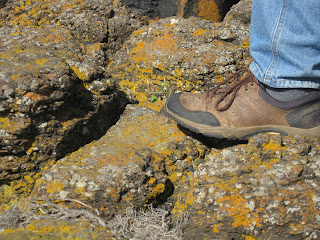
My attraction to Kitty Miller Bay, however, comes from its rugged beauty. Columns of black basalt -- studded with orange lichens -- make a dramatic statement, and in all directions, the views are breathtaking. You can even see to Pyramid Rock.
Sitting on boulders at the head of the bay, Doug and I sat for about half an hour. The sound of crashing waves and the eerie cry of gulls made conversation difficult, so we sat quietly absorbing the power of the seascape, letting the sound lull us into a peaceful state of mind.
PS
Before we left for Kitty Miller Bay, I was speaking to Angi on the phone. I mentioned our outing and she said she wished she could come to. I took lots of photos, Angi, and hope you enjoy the outing, even though you're in Mitchell. I'll show you more tomorrow.